
- Sku: 11695
Smart Poly Map / State Flags Dry Erase 10.75"x 10.75"
Smart Poly Map / State Flags Dry Erase 10.75\"x 10.75\"
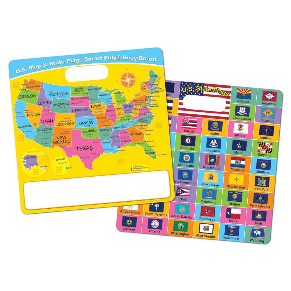
Compact, durable, and endlessly engaging, this Smart Poly Map blends geography learning with visual state flag cues on a 10.75\" by 10.75\" dry erase surface. Made from sturdy poly material, it wipes clean in seconds and stands up to daily classroom or homeschool use. The combination of clear state outlines and subtle flag imagery provides instant visual anchors that help learners memorize locations, symbols, and relationships without overwhelming them with information.
Why this map stands out
- Durable, wipeable surface: A rugged poly foundation resists ghosting and staining, keeping maps legible for ongoing lessons and repeated practice.
- Concise, kid-friendly size: At a little over 10 inches square, it fits neatly on desks, easels, or small bulletin boards—perfect for limited classroom space or cozy study corners at home.
- State flags visual cues: The integrated flag imagery provides quick recognition cues, aiding memory recall and helping students connect geography with state identity.
- Versatile learning tool: Ideal for introducing U.S. geography, practicing state locations, planning trips, or tracking travel over time with color-coded markers.
- Easy to integrate: Use with any dry erase marker, cloth or eraser, and store flat when not in use. No mounting required—simply place on a smooth surface for immediate use.
Practical use cases
- Geography warm-ups: have students quickly mark neighboring states to reinforce spatial relationships.
- State symbolism: discuss state flags and what they represent, then have learners illustrate associations directly on the map.
- Road trip journals: plan itineraries and mark destinations as you travel, using color codes for visited vs. planned stops.
- Study stations: rotate mini-activities where learners label capitals, major cities, or geographical features on the map.
- Small-group challenges: quick quizzes where teams race to mark clues on the map, boosting engagement and collaboration.
Who this is for
Geography-loving families, elementary teachers, and tutors seeking a compact, low-friction learning aid will appreciate this map. It’s particularly well-suited for classrooms with limited wall space, homeschool setups that prioritize hands-on learning, and busy counselors or activity coordinators who need a portable, repeatable teaching tool.
Care and longevity
To keep the surface pristine, wipe with a dry microfiber cloth or a damp cloth for stubborn marks. Use standard dry erase markers; avoid permanent markers. Store flat or in a sleeve when not in use to prevent scratches and preserve the flag imagery’s clarity over time.
What makes it a smart choice
This isn’t just a map—it’s a focused learning companion that merges geographic layout with symbolic cues to accelerate recall and deepen understanding. The 10.75\" square format makes it a thoughtful addition to every learning corner, delivering consistent, repeatable practice without clutter. If you’re seeking a tactile, time-saving way to teach U.S. geography and state symbolism, this Smart Poly Map is designed to deliver clear, tangible results in every session.
Smart Poly Map / State Flags Dry Erase 10.75"x 10.75"